Archival Layers and Public Interpretation for Heritage BIM:
Two Atlanta Case Studies
|
Investigations sposored by a 2021 NCPTT Grant
|
Advancements in technology make it possible to bring history to life in ways previously unimagined. Through rigorous and accurate historic interpretation that features diverse perspectives, including the narratives of historically marginalized populations, institutional research efforts have the incredible responsibility of drawing attention to the people, places, and stories of America, especially its darker and hidden histories, to cultivate new generations of well-informed citizens. Asinterpretive immersion technologies advance through digital archives, collections, and databases, so do options for layered, interactive models that can advance the potential of heritage BIM (building information modeling).
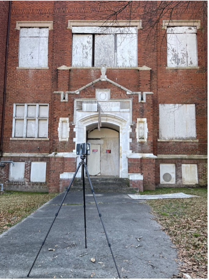
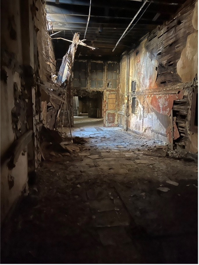
Incorporating these innovative interpretative methodologies for documentation and public outreach, this project explores two important, but rapidly deteriorating sites in Atlanta related to the ongoing struggle for civil rights: the English Avenue Elementary School (1911) and Paschal’s Motor Hotel and Restaurant (1957). Both sites are abandoned and structurally compromised, and although an array of plans in the last decade have proposed restoration and adaptive reuse projects, the immediate future of both sites is uncertain, at best. Therefore, this project leverages an existing digital documentation and research initiative to build interactive heritage BIM models of both sites to be hosted on a public-facing website. Using student research assistants and building upon content within a spring semester seminar, this project pilots workflows for leveraging rich and complex point clouds into tools for recording and safely studying perilous historic structures, amalgamating archival content to enliven history, and actively using digital documentation for preservation planning and adaptive reuse efforts. |
INNOVATION
Moving beyond the goal of simply documentary record through 3D scanning and UAV (i.e., drone) aerial photogrammetry captures, this project uses the two case studies to pioneer a layered and interactive approach to heritage BIM models, with replicable workflows.
NATIONAL NEED AND IMPACT
As two proof-of-concept case studies that demonstrates the feasibility of melding digital documentation of compromised sites with visual archival material to enhance historic interpretation and public outreach, this project offers the following, key impacts:
This project seeks to establish a precedent for future applications of construction and survey technologies in historic documentation, preservation planning, and interactive public history initiatives. These digital products can effectively expose complex, complicated histories to new audiences beyond the site’s geographical boundaries in a more engaging multi-layered interpretation format.
BACKGROUND
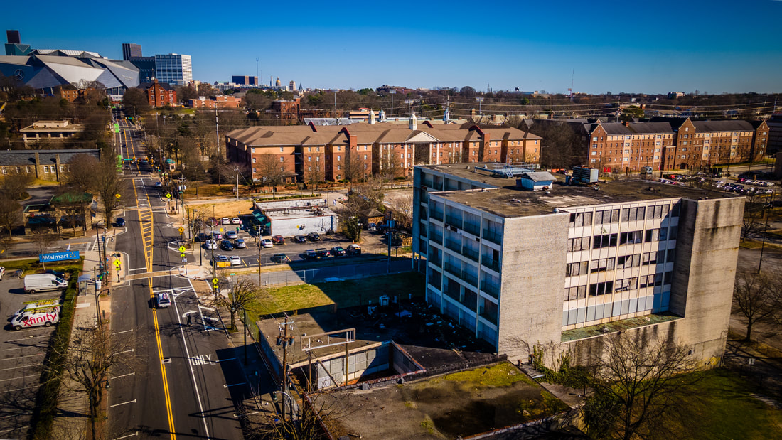
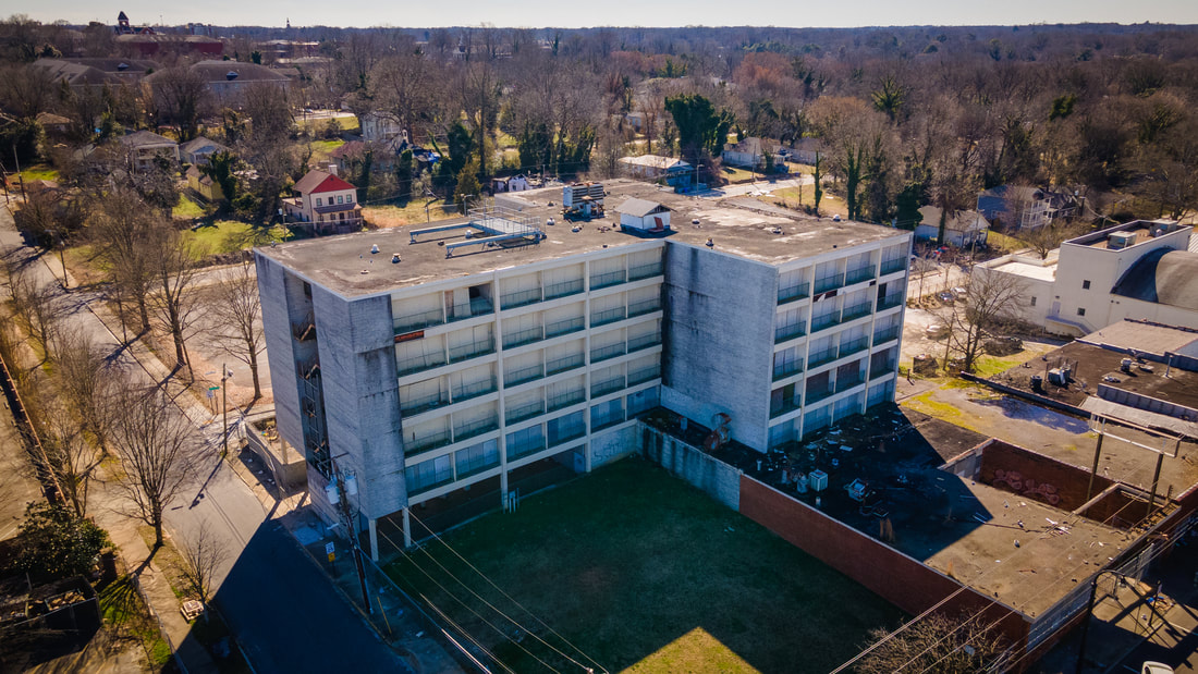
A regular feature in The Green Book and renowned for its food and hospitality, Paschal’s was a safe haven for Black travelers, where those arrested at peaceful sit-ins or marches could receive a free, hot meal after their release, and a secure place for civil rights leaders to gather. The was known as “Black City Hall” and, here, Black and white patrons gathered in the same dining room, a radical configuration for the typical landscape of the segregated south. Evolving from a humble lunch counter to large-scale restaurant and entertainment complex, Paschal’s continued to foster community through repast; John Lewis noted he last saw Martin Luther King, Jr. alive at the restaurant. Once the cornerstone of westside Atlanta that served generations of progressive advocates and policymakers, the site of Paschal’s Motor Hotel and Restaurant is currently in a precarious state. The restaurant’s features are barely recognizable along the sidewalk, only the skeletal frame of the roadside sign remains, and debris litters the shuttered balconies of the International Style hotel.
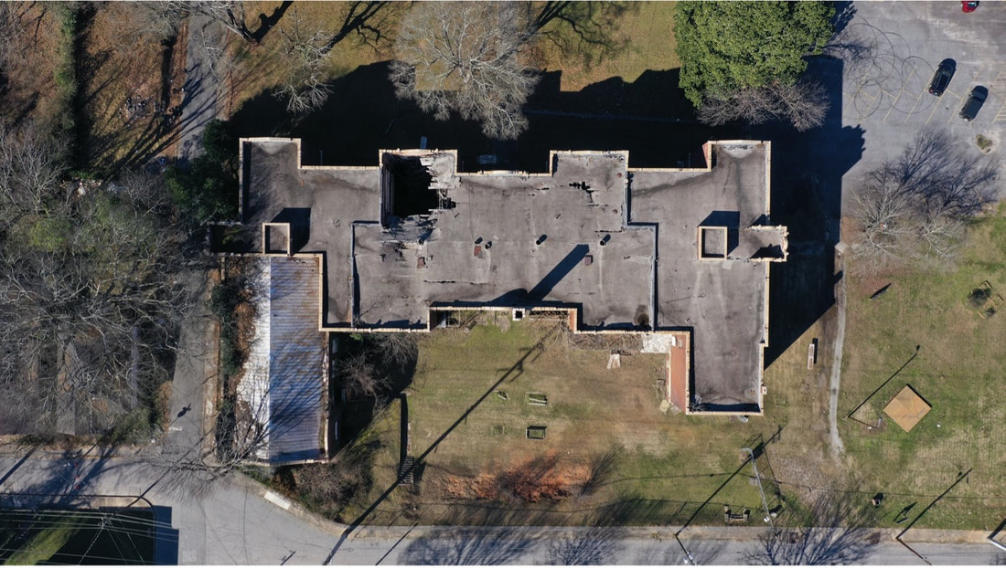
The English Tudor Revival structure of the English Avenue Elementary School (1911) is one of the oldest public schools in the city of Atlanta. It was originally designed for the residents of a white, working-class neighborhood of Western Heights, but shifting demographics changed the designation to a ‘Black school’ in 1950 and students such as Gladys Knight passed through its halls. Following Brown vs. Board of Education, an early morning bombing at the site in December 1960 demonstrated the white supremacist presence within the city, eager to express their disapproval of desegregation. The history of the site challenges Atlanta’s myth of smooth racial progress in the “city too busy to hate,” as coined by Mayor Ivan Van Allen in the 1960s.
Of note for this endeavor is the ARCH 4823/6160 Race, Space, and Architecture in the United States seminar; a course that has been on the books for a number of years but has not been offered at Georgia Institute of Technology since the fall of 2012. As we discovered in the first revival of the cours in the spring of 2021, there is much work to be done in the realm of documentation and capture of disappearing narratives in the built environment. Far too many BIPOC sites have been consciously erased or are in severe peril, especially in Atlanta. The two proposed case studies of Paschal's and the English Avenue School are distinct examples of this.
Course deliverables focus on documentation: 3D scanning, photogrammetry, the design of items for preservation planning and revitalization, as well as virtual exhibits for public outreach. Using online platforms to our benefit, the course consistently engages myriad voices from the fields of architecture, public history, and non-profits, specifically the Atlanta Preservation Center, and community stakeholders, underscoring the value of partnering with a local organization with an existing audience to give the students real-world experience and also to contribute to local organizations and communities. The cost of 3D scanning is typically prohibitive for the sites we are studying; so, this truly is a service-learning endeavor in preservation.
Moving beyond the goal of simply documentary record through 3D scanning and UAV (i.e., drone) aerial photogrammetry captures, this project uses the two case studies to pioneer a layered and interactive approach to heritage BIM models, with replicable workflows.
NATIONAL NEED AND IMPACT
As two proof-of-concept case studies that demonstrates the feasibility of melding digital documentation of compromised sites with visual archival material to enhance historic interpretation and public outreach, this project offers the following, key impacts:
- Enhancing and augmenting the captured data of 3D scanning and aerial photogrammetry. Often, the point clouds are seen as the final products, but these dense data sets offer so much more potential than static images or ethereal animations.
- Introducing students to digital survey techniques and how to incorporate these into active architectural investigations. This demystifies the technology and allows architectures students to interface with critical questions of preservation and reservation, as well as community-grounded field work.
- Providing an accessible and clear workflow, including data processing/management and secure outputs, to reproduce these methods at other sites. In many instances, the post-capture products of digital documentation feel like reinventing the wheel at each site: through two different case studies of sites of comparable size, this project will investigate how the post-capture products can be streamlined. The innovative and precisely documented workflow will provide a model for other projects to leverage archival content alongside analog and digital site surveys into accurate, experiential, and interactive geospatial reconstructions.
This project seeks to establish a precedent for future applications of construction and survey technologies in historic documentation, preservation planning, and interactive public history initiatives. These digital products can effectively expose complex, complicated histories to new audiences beyond the site’s geographical boundaries in a more engaging multi-layered interpretation format.
BACKGROUND
A regular feature in The Green Book and renowned for its food and hospitality, Paschal’s was a safe haven for Black travelers, where those arrested at peaceful sit-ins or marches could receive a free, hot meal after their release, and a secure place for civil rights leaders to gather. The was known as “Black City Hall” and, here, Black and white patrons gathered in the same dining room, a radical configuration for the typical landscape of the segregated south. Evolving from a humble lunch counter to large-scale restaurant and entertainment complex, Paschal’s continued to foster community through repast; John Lewis noted he last saw Martin Luther King, Jr. alive at the restaurant. Once the cornerstone of westside Atlanta that served generations of progressive advocates and policymakers, the site of Paschal’s Motor Hotel and Restaurant is currently in a precarious state. The restaurant’s features are barely recognizable along the sidewalk, only the skeletal frame of the roadside sign remains, and debris litters the shuttered balconies of the International Style hotel.
The English Tudor Revival structure of the English Avenue Elementary School (1911) is one of the oldest public schools in the city of Atlanta. It was originally designed for the residents of a white, working-class neighborhood of Western Heights, but shifting demographics changed the designation to a ‘Black school’ in 1950 and students such as Gladys Knight passed through its halls. Following Brown vs. Board of Education, an early morning bombing at the site in December 1960 demonstrated the white supremacist presence within the city, eager to express their disapproval of desegregation. The history of the site challenges Atlanta’s myth of smooth racial progress in the “city too busy to hate,” as coined by Mayor Ivan Van Allen in the 1960s.
Of note for this endeavor is the ARCH 4823/6160 Race, Space, and Architecture in the United States seminar; a course that has been on the books for a number of years but has not been offered at Georgia Institute of Technology since the fall of 2012. As we discovered in the first revival of the cours in the spring of 2021, there is much work to be done in the realm of documentation and capture of disappearing narratives in the built environment. Far too many BIPOC sites have been consciously erased or are in severe peril, especially in Atlanta. The two proposed case studies of Paschal's and the English Avenue School are distinct examples of this.
Course deliverables focus on documentation: 3D scanning, photogrammetry, the design of items for preservation planning and revitalization, as well as virtual exhibits for public outreach. Using online platforms to our benefit, the course consistently engages myriad voices from the fields of architecture, public history, and non-profits, specifically the Atlanta Preservation Center, and community stakeholders, underscoring the value of partnering with a local organization with an existing audience to give the students real-world experience and also to contribute to local organizations and communities. The cost of 3D scanning is typically prohibitive for the sites we are studying; so, this truly is a service-learning endeavor in preservation.
The physical survey using traditional HABS-guided methods and digital documentation has been underway at these two sites since February 2021. This method has facilitated different techniques for a geomatics approach, integrating terrestrial and aerialpoints of view through LiDAR with a Faro Focus3D X130 HDR and Faro 350s systems as well as UAVs (DJI Phantom 4 RTK, Mavic Pro 2, Mavic 3 Enterprise, Avata) to monitor the site in different seasonal and lighting conditions. The repetitive 3D LiDAR scans and photogrammetry captures that generate point cloud data also facilitate iterative studies of the building’s weathering, fostering a foundation for a much-needed historic structure report that will lead to essential, large-scale preservation and restoration projects.
Thus far, the project’s workflow has called into question the nature and scope of born-digital records within historic built fabric documentation. The HABS standards, beneficially, still insist that LiDAR scans are only one possible facet of the documentation of a project’s documentation. Although the NPS has employed 3D scanning and UAV photogrammetry in several projects, the published standards associated with scanning need substantial updates. Furthermore, the Library of Congress does not archive laser-scanned data, so these data sets still fall under the realm of the “experimental.”
Unlike the projects featured on CyArk or SketchFab, online platforms to showcase 3D digital models, this project underscores that it is essential to include site context, especially with references to structures that are harbingers of community history. As evidenced by other online platforms, such as the Smithsonian X3D project, digitized artifacts, whether at the scale of a button or an occupiable structure, can be inspected and manipulated through online interfaces that entirely divorce these objects from their surroundings. This is where the integration of archival maps and photographs will help ground and contextualize the digital documentation data.
Overall, the project aims to:
- Develop existing site assessment through the use of 3D scanning and UAVs to complete safe and non-invasive surveys of the built environment, specifically the inspection of fragile elements, to ensure the safety of the surveyor at precarious or otherwise inaccessible sites
- Explore strategies for implementing a 3D scan and UAV-survey for essential pre-preservation planning and historic structure documentation, especially for sites with urgent or immediate threats
- Pilot tools and benefits of translating 3D scanning and UAV-survey data into digital models (BIM) and measured drawings for design proposals
Explore the ongoing documentation and visualization for each project below:

